332
332
tv
eye 332
favorite 0
quote 0
a few chilly sprinkles in virginia and southern maryland. eastern shore right along the coastline, the
a few chilly sprinkles in virginia and southern maryland. eastern shore right along the coastline, the
136
136
Nov 13, 2012
11/12
by
WRC
tv
eye 136
favorite 0
quote 0
much of southern maryland near the bay hovering near 50. for the morning commute, you'll need an umbrella. rainy, chilly, by 6:00 a.m. still hovering in the upper 40s to mid-40s in the north and west. by noontime, all the rain over. should end by 9:00 or 10:00. cloudy and chilly for the lunch hour. winds still blustery, 20 miles an hour out of the north and west. we'll be holding steady in the 40s for the rest of the afternoon and down to near 40 by midnight and down to 30 by dawn tomorrow. by this time tomorrow morning, likely a widespread freeze under a clear sky. lots of sun tomorrow but highs only in the 40s to near 50. average high this time of year 59. we're not going to be anywhere near that for the next several days. cold mornings and chilly afternoons thursday, friday, and saturday. we may have a little disturbance off the atlantic seaboard sunday into monday. may give you some rain. stay tuned. we'll keep you posted on that. now with first 4 traffic, here's danella. good morning. >> thanks, tom. if you're about to head out of the
much of southern maryland near the bay hovering near 50. for the morning commute, you'll need an umbrella. rainy, chilly, by 6:00 a.m. still hovering in the upper 40s to mid-40s in the north and west. by noontime, all the rain over. should end by 9:00 or 10:00. cloudy and chilly for the lunch hour. winds still blustery, 20 miles an hour out of the north and west. we'll be holding steady in the 40s for the rest of the afternoon and down to near 40 by midnight and down to 30 by dawn tomorrow. by...
177
177
tv
eye 177
favorite 0
quote 0
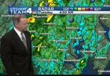
southern maryland, northern virginia. all these areas in light green. just a few sprinkles of chilly rain. that's in anne arundel, calvert, charles, st. mary's, southern prince george's county. also getting a few sprinkles across the potomac and fairfax county and down 95 to prince william and stafford and spotsylvania and parts of fauquier county. there may be a few wet snowflakes along the blue ridge just to the northwest of warrenton, and temperatures are all above freezing, though. we are in the mid and upper 30s. low 40s. it's going to be a damp and chilly morning as you head out this wednesday morning. you'll need an umbrella as we're going to have the sprinkles around for a time into the morning hours. today later and into tonight, we've got a winter weather advisory in effect for maybe as much as four inches of snow. that's going to be up into southern pennsylvania. lighter amounts farther south and closer to the metro area. i'll show you how much i think we're going to get coming up here in a few minutes. as we go forward, the storm system well
southern maryland, northern virginia. all these areas in light green. just a few sprinkles of chilly rain. that's in anne arundel, calvert, charles, st. mary's, southern prince george's county. also getting a few sprinkles across the potomac and fairfax county and down 95 to prince william and stafford and spotsylvania and parts of fauquier county. there may be a few wet snowflakes along the blue ridge just to the northwest of warrenton, and temperatures are all above freezing, though. we are...
248
248
Nov 15, 2012
11/12
by
WRC
tv
eye 248
favorite 0
quote 0
also, much of southern maryland, eastern shore, 40s there. and the four-day forecast showing this unusual chill continuing. it does look like we will remain colder than average into the weekend. cloudiness today. sunny saturday. right now the latest on the coastal storm. it will be farther out to sea. and it may not affect us at all with any precipitation. stay tuned. chilly mid week. i'll be back in 10 minutes. good morning. >>> good morning. kicking off our first traffic report first with the rails. glen mont, a track problem there. so you're seeing tracking on the red line between wheaton and glen mont. over to the roadways, i-270 southbound germantown picking up volume. out of frederick, you are pretty much jammed. very sluggish towards clarksburg in tt area. 66, usual delays as you wake your way past 70 east bound. your travel lanes are open. you're starting to slow down a bit to the beltway. under speed. that drive will take you 12 minutes. eun, back over to you. >>> 6:22. the spray that will supposedly keep your man faithful. >> a spra
also, much of southern maryland, eastern shore, 40s there. and the four-day forecast showing this unusual chill continuing. it does look like we will remain colder than average into the weekend. cloudiness today. sunny saturday. right now the latest on the coastal storm. it will be farther out to sea. and it may not affect us at all with any precipitation. stay tuned. chilly mid week. i'll be back in 10 minutes. good morning. >>> good morning. kicking off our first traffic report first...
220
220
Nov 16, 2012
11/12
by
WRC
tv
eye 220
favorite 0
quote 1
that area in green is sprinkles coming down northern neck, southern maryland, eastern shore. west and north, the sky is clearing out. hour by hour today, we'll have light breezes coming in out of the north. sun back by noontime. during the afternoon. hitting mid-50s by afternoon. overnight tonight, if you're heading out this friday evening, it will be clear and in the 40s through the evening with a light wind. i'm back in ten minutes with your seven day outlook. >> eastbound braddock road at club side lane. your right lane is blocked. no injuries were reported. let's talk about bw parkway between i-95 in maryland. over to 50 in annapolis, a live look as you make your way past two inbound and outbound clear to the beltway. from the beltway, here's a live look at 410, making your way inbound. you'll start to hit the brakes right around landover road but not too bad as you make your way to kenilworth avenue. >>> breaking news on an amber alert in virginia. let's get more from megan mcgrath. >> reporter: the 1-year-old girl who was missing, alexis carlisle, she has been found in
that area in green is sprinkles coming down northern neck, southern maryland, eastern shore. west and north, the sky is clearing out. hour by hour today, we'll have light breezes coming in out of the north. sun back by noontime. during the afternoon. hitting mid-50s by afternoon. overnight tonight, if you're heading out this friday evening, it will be clear and in the 40s through the evening with a light wind. i'm back in ten minutes with your seven day outlook. >> eastbound braddock road...
121
121
tv
eye 121
favorite 0
quote 0
prince george's, montgomery, arlington, fairfax counties, much of southern maryland, northern neck, eastern shore generally above freezing, but it's in the 40s. let's take a look at what may be happening here for the rest of the afternoon. ought to get sunshine breaking out and during the day on tuesday for election day, sun in the morning and get some clouds beginning to move in tuesday night as a coastal storm begins to develop. all this area in green and orange, this is rain. it's going to be coming into colder air. this area in blue, this is potential snow. this is as of wednesday late afternoon into wednesday night. we could have that rain changing to snow in our region. rain and wind right along the atlantic seaboard all the way up to new york city into new england. the storm is going to track right along the coast, it appears, and move into new england by thursday. by wednesday, we'll dry out. our first snow of the season may be happening wednesday afternoon and wednesday evening. cloudy morning for your morning commute by 6:00 a.m. still a bit of a blustery wind, 30s to near 40 degr
prince george's, montgomery, arlington, fairfax counties, much of southern maryland, northern neck, eastern shore generally above freezing, but it's in the 40s. let's take a look at what may be happening here for the rest of the afternoon. ought to get sunshine breaking out and during the day on tuesday for election day, sun in the morning and get some clouds beginning to move in tuesday night as a coastal storm begins to develop. all this area in green and orange, this is rain. it's going to...
338
338
tv
eye 338
favorite 0
quote 1
much of southern maryland and the northern neck. now let's go forward and see what may be happening with this coastal storm. throughout the day today, we'll have sunshine breaking out this afternoon. and then as we get into wednesday and wednesday evening is when we'll begin to see the effects of this storm. here's wednesday at 7:40 in the morning, just a lot of clouds. this area of green and orange, a lot of heavy rain, a rapidly developing coastal storm off the carolinas at that point. let's go forward into wednesday afternoon. this is 3:00 wednesday afternoon. this is moderate to heavy rain. these areas of yellow and orange heading off to the west. it's going to be drawing in colder air as it does develop off the atlantic seaboard. as a result, we'll see it change to snow. does look like areas in the dark blue a mix of rain and snow. these areas in the lighter blue and white could be accumulating snow for parts of western maryland, maybe right along the blue ridge and wet snowflakes and rain mixing in western and northern suburbs
much of southern maryland and the northern neck. now let's go forward and see what may be happening with this coastal storm. throughout the day today, we'll have sunshine breaking out this afternoon. and then as we get into wednesday and wednesday evening is when we'll begin to see the effects of this storm. here's wednesday at 7:40 in the morning, just a lot of clouds. this area of green and orange, a lot of heavy rain, a rapidly developing coastal storm off the carolinas at that point. let's...
160
160
tv
eye 160
favorite 0
quote 0
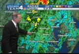
southern maryland getting some of that rain reaching the ground. a close-up view of storm team 4 radar showing it from st. mary's county and right around the bay. parts of calvert and looks like anne arundel may be getting a few sprinkles. farther west a lot of this is not reaching the ground. temperatures thankfully they're above freezing. that's going to play a big factor. that will keep the road temperatures above freezing. it's cold from the upper 30s to near 40. have an umbrella handy. sprinkles around 8:00 a.m. cold air mixes in, changing the rain to wet snow this afternoon. and a winter weather advisory those counties in blue. up there on the pennsylvania border, they can get four inches. locally, i think maybe just a dusting to a half inch on grassy areas only melting on roads and higher amounts just north and east of washington. and then tomorrow we'll get the sun back. blustery wind today gusting to 30, also around tomorrow. weekend looks great. all the way into veterans day observed monday with warmer afternoons and chilly mornings. dane
southern maryland getting some of that rain reaching the ground. a close-up view of storm team 4 radar showing it from st. mary's county and right around the bay. parts of calvert and looks like anne arundel may be getting a few sprinkles. farther west a lot of this is not reaching the ground. temperatures thankfully they're above freezing. that's going to play a big factor. that will keep the road temperatures above freezing. it's cold from the upper 30s to near 40. have an umbrella handy....
153
153
Nov 16, 2012
11/12
by
WRC
tv
eye 153
favorite 0
quote 0
those patches of green in southern maryland, northern neck, eastern shore. those are sprinkles passing south and east of the metro area and moving off to the north and east. areas in the light blue are in the 40s. that includes much of virginia, southern maryland, and lower eastern shore farther north from charles county, prince george's, and anne arundel north into montgomery county and the district. generally, upper 30s to around 40 degrees. loudoun virginia from west to the shenandoah valley. upper 30s. much of the shenandoah valley west, it's below freezing in the upper 30s and low 20s. upper 20s. by noon, a little sun breaking out, upper 40s. by midafternoon, ought to hit the low to mid-50s and getting increasingly sunny. bit of a blustery northeast wind. i'll show you your friday evening forecast in ten minutes. a look at traffic with danella. good morning. >> good morning. >>> we have a disabled vehicle. let's start 395 as you make your way northbound toward 110, it's blocking the right lane in this area. keep an eye on the road work. as you make your
those patches of green in southern maryland, northern neck, eastern shore. those are sprinkles passing south and east of the metro area and moving off to the north and east. areas in the light blue are in the 40s. that includes much of virginia, southern maryland, and lower eastern shore farther north from charles county, prince george's, and anne arundel north into montgomery county and the district. generally, upper 30s to around 40 degrees. loudoun virginia from west to the shenandoah...
193
193
Nov 13, 2012
11/12
by
WRC
tv
eye 193
favorite 0
quote 0
most of southern maryland and much of virginia and the district. north of washington, these areas of yellow and orange, raining harder in northern montgomery county from poolesville over to damascus. and western howard county, mt. aerie, and carroll county, westminst westminster, heading off to the north and east. drying out in the mountains where temperatures are near freezing. east of there, it is chilly. we're just in the 40s all across the region. we're going to stay in the 40s the rest of the day. here is your storm team 4 hour by hour forecast for the day. by 8:00 a.m., still chilly and breezy and wet with some passing showers in the mid-40s. by 9:00 or maybe 10:00 at the latest, the rain should end. by lunch hour, cloudy, chilly, breezy, temperatures in the 40s. winds gusting to around 20 miles an hour. ought to clear out by mid to late afternoon. little sunshine breaking out right before sunset. cold start tomorrow morning. we'll look at that, the rest of the week and the weekend, storm team 4 outlook in ten minutes. now a look at traffic w
most of southern maryland and much of virginia and the district. north of washington, these areas of yellow and orange, raining harder in northern montgomery county from poolesville over to damascus. and western howard county, mt. aerie, and carroll county, westminst westminster, heading off to the north and east. drying out in the mountains where temperatures are near freezing. east of there, it is chilly. we're just in the 40s all across the region. we're going to stay in the 40s the rest of...
217
217
tv
eye 217
favorite 0
quote 0
right now getting rain east of washington through southern maryland and south of washington. just a little to the west of i-95 and from fredericksburg south, a little more moderate rain. it's chilly. we're only in the 30s to around 40 degrees. chilly light rain off and on until around noontime. changes the rain to wet snow accumulating on grassy areas during the afternoon into this evening. i'll show you how much i think we may get. >>> early morning commute still looks pretty good. bw parkway i-95 from the baltimore beltway to capital beltway. over to 50 from annapolis. traveling towards the beltway in both directions. no issues there. even from the beltway as you head towards new york avenue. travel lanes are open. inbound and outbound nice and clear. inbound, just picking up a little bit of momentum. no major delays and no accidents to report. still checking the rails. so far, no reported delays along the metro, marc, or vre. aaron and eun? >> thank you, danella. >>> we'll break down how the key swing states helped determine who won the presidential race. >>> and what went
right now getting rain east of washington through southern maryland and south of washington. just a little to the west of i-95 and from fredericksburg south, a little more moderate rain. it's chilly. we're only in the 30s to around 40 degrees. chilly light rain off and on until around noontime. changes the rain to wet snow accumulating on grassy areas during the afternoon into this evening. i'll show you how much i think we may get. >>> early morning commute still looks pretty good. bw...
185
185
tv
eye 185
favorite 0
quote 0
montgomery, arlington, fairfax, prince george's counties, much of southern maryland away from the waters in the 30s, as is the eastern shore and the northern neck of virginia. farther west, shenandoah valley into the mountains, most locations there are below freezing. it's going to stay that way for another couple of hours. morning commute by 7:00 a.m., bundle up. it's still going to be cold and breezy. mid-30s to low 40s. by the noon hour, we'll be warming into the low 50s. and still a bit of a blustery wind, but we'll have that bright sun. the rest of the afternoon will be sunny. afternoon highs reaching around 60. storm team 4 four-day forecast into the weekend. tomorrow still colder than average. average high this time of year, 61. morning lows near 40. afternoon highs right near the average on saturday with a few afternoon clouds. sunny sunday, finally getting warmer than average. looks like we'll be climbing into the upper 60s. maybe some locations near 70 degrees. midafternoon on sunday. a delightful weekend coming up. and then for veterans day observed monday, sun in the morning,
montgomery, arlington, fairfax, prince george's counties, much of southern maryland away from the waters in the 30s, as is the eastern shore and the northern neck of virginia. farther west, shenandoah valley into the mountains, most locations there are below freezing. it's going to stay that way for another couple of hours. morning commute by 7:00 a.m., bundle up. it's still going to be cold and breezy. mid-30s to low 40s. by the noon hour, we'll be warming into the low 50s. and still a bit of...
180
180
tv
eye 180
favorite 0
quote 0
farther out to sea, bringing some rain into the eastern shore and perhaps around southern maryland and northern neck. by noontime, 1:00, the precipitation drawing in some cold air may be changing to wet snow for the eastern suburbs and around the bay. i don't think anything is going to stick. if it does happen, it will be melting on roadways. that may continue into the evening hours. it will finally pull away as it heads out to sea. it will dry out and get sunshine back and improving news into the week and weekend. highs today in the 40s. great weather to get out and vote, not much wind. and then tomorrow, those clouds around and rain/snow east of the metro area ending wednesday night. sunshine back thursday through the weekend into the first part of next week with a warming trend. in fact, highs near 60 or so saturday, sunday, and veterans day on monday. danella, how's traffic? >>> checking the rails, a couple of delays. first with metro, seeing a delay on the orange and blue line because of a disabled train. this is at farragut west. you're going to see single tracking between farrag
farther out to sea, bringing some rain into the eastern shore and perhaps around southern maryland and northern neck. by noontime, 1:00, the precipitation drawing in some cold air may be changing to wet snow for the eastern suburbs and around the bay. i don't think anything is going to stick. if it does happen, it will be melting on roadways. that may continue into the evening hours. it will finally pull away as it heads out to sea. it will dry out and get sunshine back and improving news into...
198
198
Nov 13, 2012
11/12
by
WRC
tv
eye 198
favorite 0
quote 0
southern maryland, including prince george's county and to the western part of the northern neck. this rain is going to be with us for another couple of hours at least. behind that, all these areas in dark blue are below freezing. ohio, much of west virginia, pennsylvania, into the midwest. it's down into the 20s many of those locations. right around the metro area, we're in the 40s. we're going to hold steady in the 40s throughout the day, hour by hour. you'll need an umbrella. through 9:00 a.m., we'll have that rain and dry after that. a chilly afternoon and breezy. by dawn tomorrow, near freezing. starting off tomorrow, much of the area a freeze. we'll have a clear sky, sunny tomorrow with a high near 50. chilly mornings and chilly afternoons all the way into the weekend. remaining dry into maybe half of sunday. right now looks like sunday afternoon and evening into monday we could get some rain. first 4 traffic now with danella. >> good morning. >>> i-66 eastbound mile marker 49, an incident blocking the right lane. turns out to be a disabled vehicle. guess what? it's now move
southern maryland, including prince george's county and to the western part of the northern neck. this rain is going to be with us for another couple of hours at least. behind that, all these areas in dark blue are below freezing. ohio, much of west virginia, pennsylvania, into the midwest. it's down into the 20s many of those locations. right around the metro area, we're in the 40s. we're going to hold steady in the 40s throughout the day, hour by hour. you'll need an umbrella. through 9:00...
192
192
tv
eye 192
favorite 0
quote 0
we've got that crescent moon in the southern sky right now. it is cold. we need your warmest winter coat. we have it down in the 30s. that covers just about all of virginia and all of maryland. the lighter blue areas around the bay, tidal potomac. you can see there, it's in the 40s, low 40s. the dark blue areas, this is the 20s here in the highlands of western maryland and west virginia. it's only in the low 20s there. right around the beltway, montgomery, arlington, fairfax counties, generally above freezing. below freezing much of virginia and maryland. hour by hour, we'll have the winds a bit blustery. by 7:00 a.m., still cold and breezy. winds gusting to around 20 miles an hour as we get through noontime and during the middle of the afternoon. by then, we'll be aouround 60 degrees. sunset 4:59. a look at traffic this friday morning with danella. >> good morning. first 4 traffic. >>> starting with i-270. going to slow down southbound out of frederick. sluggish as you make your way past 109. past 109 heading towards clarksburg continuing to germantown.
we've got that crescent moon in the southern sky right now. it is cold. we need your warmest winter coat. we have it down in the 30s. that covers just about all of virginia and all of maryland. the lighter blue areas around the bay, tidal potomac. you can see there, it's in the 40s, low 40s. the dark blue areas, this is the 20s here in the highlands of western maryland and west virginia. it's only in the low 20s there. right around the beltway, montgomery, arlington, fairfax counties, generally...
376
376
Nov 15, 2012
11/12
by
WRC
tv
eye 376
favorite 0
quote 0
right in washington and southern maryland where it's in the low to mid-40s. later today, up near 50. maybe sun coming up. still, this unusually chilly pattern continuing into midweek next week. looking dry. the coastal storm looks to be >> and that's your latest weather. >> all right, al. thank you very much. fun gadgets to get you up off that couch and moving. we're going to dance. you're going to dance. >> i am? >> we're not allowed to do that. [ male announcer ] this is bob, a regular guy with an irregular heartbeat. the usual, bob? not today. [ male announcer ] bob has afib: atrial fibrillation not caused by a heart valve problem, a condition that puts him at greater risk for a stroke. [ gps ] turn left. i don't think so. [ male announcer ] for years, bob took warfarin, and made a monthly trip to the clinic to get his blood tested. but not anymore. bob's doctor recommended a different option: once-a-day xarelto®. xarelto® is the first and only once-a-day prescription blood thinner for patients with afib not caused by a heart valve problem, that doesn't
right in washington and southern maryland where it's in the low to mid-40s. later today, up near 50. maybe sun coming up. still, this unusually chilly pattern continuing into midweek next week. looking dry. the coastal storm looks to be >> and that's your latest weather. >> all right, al. thank you very much. fun gadgets to get you up off that couch and moving. we're going to dance. you're going to dance. >> i am? >> we're not allowed to do that. [ male announcer ] this...
 Live Music Archive
 Librivox Free Audio
 Metropolitan Museum
 Cleveland Museum of Art
 Internet Arcade
 Console Living Room
 Books to Borrow
 Open Library
 TV News
 Understanding 9/11